Importing Shape Files
Updated May 08, 2025
This article applies to:
- Terrain 3D
- Terrain Forestry
- RoadEng Civil
- RoadEng Forestry
This Knowledge Base article is an excerpt from one of our tutorial files. The files referenced in the article, as well as the full tutorial document, are available in our Tutorial Installer.
Contour Map Example
Another common file format used is shape files. The Terrain Module will read (and write) Shape files including attributes.
 File | Open. Change Files of type to ArcView Shape (*.shp).
Select <Terrain>\ Import\topo.shp. Press Open.- Set the Import Options dialogue box to match those shown in the figure below and press OK.
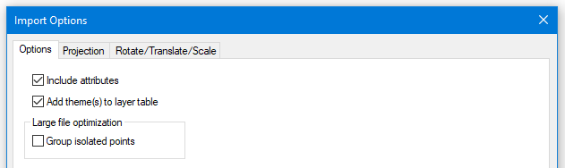
Figure 1: Shape Import Options Dialogue
After the import is complete the Plan window should appear as shown in the figure below.

Figure 2: Imported file topo.shp
Note: If you click on any of the contour lines, the Status Window shows an elevation of 0.0. The elevation information has been saved in a separate attribute. Some Shape files save the elevation information with the coordinates; others (as in this case) save elevations in an attribute...
The next steps will show how to extract the elevations from an attribute and assign them to the contours so they can be used to create a TIN model
- Home | Select button| All Features from dropdown. Click on the Feature Properties
 located in the bottom Status Bar. Ensure Elevations property is checked.
 - Click on the Status Options
 button at the bottom of the Feature Properties panel. Press Add/Remove … Scroll down to the bottom of the list on the left-hand side and locate the folder call "topo". From this folder add the item Contour. Press OK twice to return to the main screen
Note: You may notice in the Status elevations fields are all 0.0. The attributes must be assigned so that the program knows where to get the values from elevations.
- Feature Tools | Assign. In the Z row select Attrib click the Attrib... button. Click on plus button next to topo and select CONTOUR | Add button. OK twice. Values should now be displayed in elevation.

Figure 3: CONTOUR Attribute
- FileNew. Do not save changes.